

This monsoon season has seen some of the most devastating floods in many parts of India, with many people in states like Bihar, Uttar Pradesh, and Assam continuing to grapple with the effects of the flooding. Especially in regions near water bodies like rivers, sustained torrential rain can result in a rapid rise in water levels, putting hundreds of thousands of people at risk. Over the past several months, along with the Central Water Commission (CWC), we have deployed our flood forecasting initiative and sent numerous public alerts to people in impacted regions across India. These alerts provide timely, updated, and critical information that can help users make informed decisions on their safety, and that of their families and friends. Any user in the affected region with an Android smartphone with location services enabled will receive these alerts.
To better help you understand how to effectively use and interpret these alerts, here is an example of the notification shown to users who have location services on and we can place them in an area expected to be impacted by an impending flood.
We are currently issuing these notifications in English, Hindi, and Bengali depending on the device language and location of users. For example, a user in Bihar will get the notification in English and Hindi while a user in West Bengal will get the notification in English and Bengali.

You can also use Search to simply enter a query on a flood-affected area to see key information on the current situation in that region. See the example below (note that this information is timely, and may change depending on whether there happens to be a flooding situation when the query is made.
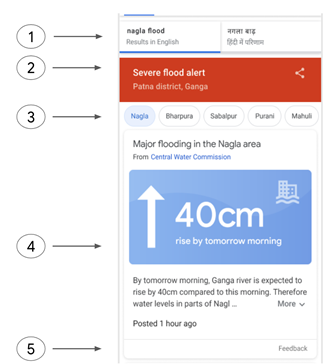
| Multilingual support (mobile only)An indication of the severity of the floodingLocation chips to enable people in the affected area that people can tap to easily change the search results and get information on more specific locations in their search area. An infographic showing depth information, which is highly relevant for people in affected areasA localized risk statement, explaining the change in scenario | |
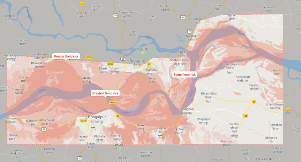
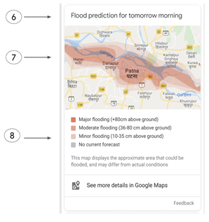
| An indication of the time of the predictionWhere possible , we provide a detailed color-coded risk map of the areas likely to be inundated with floodingA legend helping users interpret the map |
If there is a current flooding situation in the area, you will see a visual overview of key information including the rise or fall in the water level in the next day with a description of the recent situation containing specific guidance where available. You will also see a color-coded map indicating the flooded areas — clicking on this map will open a larger, more detailed view in Google Maps where you can zoom in to get a better understanding of water levels in specific regions. You can use this feature no matter where you are in India by searching for “flooding” and the name of an affected location on Search or Maps; it can be very useful to stay updated, especially if you have friends or family in the affected areas.
We continue to remain committed to using technology to help people especially during natural disasters, and continue to work closely with local authorities to bring timely, relevant, and useful information to people who most need it.
32 comments
Comments are closed.